I don’t believe in conspiracy theories—I make them! On April 10, 2010, the plane carrying Polish President Lech Kaczyński crashed on the outskirts of Smolensk, Russia. The incident gave rise to much speculation and numerous conspiracy theories, and the full truth may never be known. However, with Google, anyone can snoop around the crash site a little.
Recently, the National Geographic Channel’s Air Crash Investigation series covered the death of the Polish president. The film is based on the official Russian investigation reports but also gives a voice to former Polish Interior Minister Jerzy Miller, who clearly had some reservations about the Russians’ credibility. In the end, both the Russian and Polish investigations identified pilot error and poor weather as the main causes of the crash, though the Polish report also criticized the work of Russian air traffic controllers and the condition of the airport. Numerous details remain unresolved to this day.

Papa-Lima-Foxtrot 101
The story begins on April 10, 2010, when the Polish Air Force plane with the call sign PLF 101 took off from Warsaw Airport at 07:27 UTC with 89 passengers on board. Among them were prominent Polish dignitaries, including the president, military officers, and relatives of victims of the Katyn massacre, traveling to a commemoration marking its 70th anniversary. The aircraft, a Russian-made Tupolev Tu–154M, was in excellent technical condition. The cockpit was manned by four elite pilots from the Polish Air Force, chosen from among the country’s best: Captain Arkadiusz Protasiuk, First Officer Robert Grzywna, Flight Engineer Andrzej Michalak, and Navigator Artur Karol Ziętek. The destination was Smolensk North Airport, just 16 kilometers from the Katyn memorial. This military airfield, built in the 1920s, began partial civilian use in 2009 after the disbandment of the stationed air regiment. Its military character remained, it had no ICAO (International Civil Aviation Organization) certification, and its air traffic controllers spoke no English, only Russian. Of the Polish crew, only the captain spoke Russian. Thus, all radio communication during the approach fell entirely on him, even though regulations assigned this task to the navigator—while the captain was supposed to focus solely on flying the plane.

According to the film and contemporary reports, the airport had no Instrument Landing System (ILS), but Alexander Stepchenkov, Smolensk’s airport operations chief, claimed the opposite. If anyone knew whether there was such a system, it would have been him. Strangely, the film doesn’t explore this direct contradiction. The ILS question comes up later as well, but we get no definitive answer. The airport was shrouded in dense fog; controllers said landing was impossible and strongly advised the Polish pilots against it. Yet Captain Protasiuk insisted on continuing the approach, planning to execute a go-around on autopilot if landing failed. The pilots’ decision was influenced by the political weight placed on the landing by their superiors. President Kaczyński considered the event highly significant, as did Lieutenant General Andrzej Błasik, commander of the Polish Air Force. The cockpit voice recorder revealed that protocol chief Mariusz Kazana and General Błasik both entered the cockpit and commented on the landing. The pilots likely remembered when another Air Force captain refused a dangerous landing in Tbilisi under similar circumstances—he was dismissed afterward, though he’s still alive. Protasiuk, however, at that moment only feared for his job, unaware that far more was at stake.

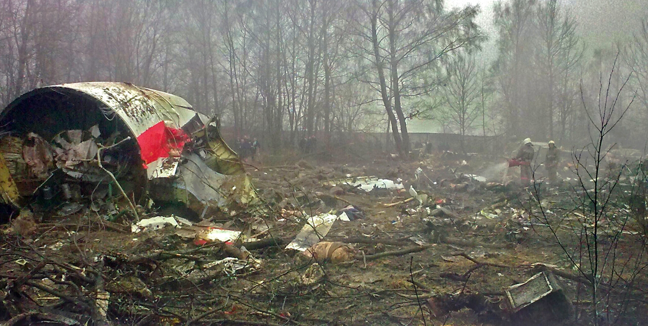
Protasiuk’s Courage
ATC cleared the presidential plane to descend to 100 meters and instructed it to go around afterward. But the maneuver failed: the plane descended too low, clipped tree tops, and at 07:41 UTC, crashed into the ground near the airport. No one survived—the disaster wiped out roughly a quarter of Poland’s political elite. Let’s take a look at the site with Google Earth! The airport’s coordinates are 54°49.5′N and 32°01.5′E. Google Earth is not just a map but a time machine: set the timeline in the upper left corner to April 9, 2010, and you’ll see the untouched landscape. On April 11 imagery, the wreckage is clearly visible, about 435 meters east of the runway’s eastern end. By June 25, only a bulldozed pit remains. Everything—even the topsoil—was cleared away. Using Google Earth’s ruler tool, we can make some measurements: the runway is exactly 2,500 meters long, oriented east-west at 266.7°. The wreckage is scattered over about 390 meters in a straight line, oriented WSW at 256.0°, meaning the plane was flying nearly 10° left of the runway heading when it crashed.

Comparing the landscape to maps of domestic military airfields, it’s easy to get oriented. East of the runway’s end, light parallel lines in the grass mark the approach lighting system. Near the runway’s end is a small building and the shadow of a tower—likely the SZP–50 glide path transmitter, Russia’s equivalent of the ILS, according to on-site photos. So, Smolensk did have such a system, though we don’t know if it was operational. Further on, at 500, 1,000, and 6,300 meters from the threshold, small fenced structures appear—probably marker beacon buildings. Near the runway midpoint stands the RSP–6 radar landing system, a typical truck-mounted unit for Soviet military fields. It can measure altitude but needs calibration after setup and must not be moved afterward. If you try approaching the airport in Google Earth’s flight simulator, you’ll notice the runway sits on a plateau with a valley in front—it feels like trying to land on a tabletop.
That’s all we can deduce from satellite images, but Picasa’s photo archive contains ground photos too. Enthusiastic amateur investigators like Sergey Amelin and his friends thoroughly examined the crash site, focusing on tree branches sheared off by the plane to reconstruct the last few hundred meters of flight. When the presidential plane began its approach, fog was already extremely dense, visibility dropping below 400 meters. The reconstruction shows the aircraft approached about 60–70 meters south of the runway centerline and was descending too quickly. The official investigation found the pilots had mis-set the barometric altimeter and ignored ground proximity warnings. They relied on the radio altimeter, which measures the distance to the ground directly below. The valley before the runway may have tricked them: the instrument showed the distance from the valley floor while they were already lower than the runway plateau.
Why did Captain Protasiuk descend so boldly toward the airport in such dense fog, when he could see nothing?

Instrument Landing Systems
The Instrument Landing System (ILS) was developed in the 1930s and was already in use by both Allied and German aircraft during World War II. ILS was a British patent, and purchasing it would have been costly for the Soviet Union, so they opted to develop their own system instead. This became the SZP–50.
Both systems transmit localizer and glide path signals using antennas placed at the end of the runway. When an aircraft is flying precisely along the landing path, in the center of the radio beam, the indicators on the ILS instrument in front of the pilot remain centered. Regardless of darkness, dense fog, or low cloud ceilings, if the aircraft follows this path, it will arrive exactly at the runway threshold.
If the aircraft deviates from the landing path either laterally or vertically, the receiving antenna detects an imbalance in the signal beams, which is reflected on the ILS instrument as needle deflections. Based on this, the pilot—or the autopilot—can make corrections during the approach.

The ILS instruments feature prominent red warning flags that appear when the instrument is turned off, malfunctioning, or when the signal reception is intermittent. In such cases, an approach must not be conducted relying on the ILS. If PLF 101 had not been receiving signals from the Smolensk landing system, Captain Protasiuk would have seen these flags.
The ILS and the Russian SZP–50 are strikingly similar; the most significant difference is that the localizer and glide path signals are swapped.
The original instrumentation of Soviet-designed Tu–154 aircraft was compatible with both systems. In the cockpit, a selector switch allowed pilots to choose between SZP–50 and ILS.
In 1984, a MALÉV Tu–154B–2 passenger plane attempted to approach runway 31R at Ferihegy Airport with the switch mistakenly set to SZP–50, even though Ferihegy operated an ILS system. As a result, the aircraft deviated from the approach path and struck the localizer antenna at the end of the runway. The wing flap sustained minor damage, but the crew managed to execute a go-around and, after a circuit, landed safely.
Following the incident, MALÉV secured this selector switch on all Tu–154 aircraft by fastening it in place and covering it with a robust, latched guard to prevent accidental switching.
A similar mishap occurred in the 1980s when a technician at a military airfield incorrectly connected the localizer antenna cables during maintenance. The resulting short circuit caused the localizer beam to shift, and during the next night flight, a Mi–24 attack helicopter nearly ended up in a nearby village’s carcass pit. Fortunately, the pilot noticed trees swaying in the searchlight beam and realized just in time that he was in the wrong place.

Let’s think through what happens if the localizer and glide path signals are swapped. Suppose the aircraft is approaching too high. Because the signals are reversed, the ILS shows not a vertical deviation but a drift to the left. The pilot corrects by turning right—and now there is an actual lateral deviation, which the instrument interprets as a vertical error. The pilot corrects both and lines up according to the instrument.
In reality, a purely vertical or purely horizontal deviation is rare, and as the example above shows, any incorrect correction due to faulty indications immediately creates an error in the other axis as well. While the aircraft is still far from the runway and flying roughly in the correct direction anyway, the system can seem to work even with the beams swapped. The pilot should notice that the aircraft is not responding at the proper rate or magnitude, but in heavy fog under intense stress, this may go unnoticed.
The real trouble starts when the aircraft is close to the runway. The ILS antennas are not symmetrically positioned: the localizer transmitter is located at the far end of the runway, slightly above the touchdown zone, while the glide path transmitter sits near the runway midpoint but off to the side, displaced from the approach path. At long range, this difference is negligible, but at close range, it becomes significant. If the ILS is working properly, this poses no problem because each beam correctly aligns in its respective plane. However, if the two beams are swapped, the guidance will become completely misleading—and as we’ve seen, the pilot’s corrections will also be wrong.
Conclusion
One possible explanation is that Captain Protasiuk was effectively flying blind, relying entirely on the Tu-154’s autopilot. In theory, a precision instrument approach can enable a landing even with zero visibility. In practice, however, every airport has its own approach minimums, and typically 200–800 meters of visibility are required for landing.
Polish military pilot Mikhal Fisher suggested as early as 2010 that incompatibility between the ILS and the Russian SZP–50 system might have played a role in the disaster. The official investigations, however, seemed to gloss over this question.
Both Russian and Polish investigators assumed that the pilots attempted to land by relying on non-precision radio beacons and manually controlling altitude, rather than executing a full precision approach. The Polish report also drew attention to the neglected state of the Russian airfield. According to the report, the radars were unreliable, and the approach lighting was partially burned out or obscured by bushes. Although the crew did not request it, the ground radar operator began giving guidance during the approach, indicating whether the aircraft was on the glide path or not. The Polish report highlights that the operator repeatedly claimed the plane was on the glide path when it was not.
When the Terrain Awareness and Warning System (TAWS) issued a “PULL UP” alert, the crew assumed it was due to the Smolensk military airfield not being open to civilian traffic and not appearing in the aircraft’s database, leading the computer to believe a ground collision was imminent. There is a TAWS setting that can suppress false alerts when landing at an airport not included in the database, but the crew did not activate it.
The trees along the runway approach were overgrown. Looking at Sergey Amelin’s photos, these claims come as no surprise—the area around the airport resembled a shantytown. Rusting car wrecks, trash, and scattered debris were everywhere. Among the crumbling buildings, the occasional cow wandered. Reading the reports, one gets the impression that the Russians preferred to ignore the miserable state of things—the fact that much of the once-glorious Red Army’s technology had been reduced to little more than scrap metal.


The Polish political leadership refused to accept that attempting to land in dense fog was reckless. Later, they were equally unwilling to accept that the tragedy could not be blamed entirely on the Russians. Still, it’s hard to believe that experienced pilots would seriously try to navigate based only on NDB beacons and a map.
The Tu-154’s flight control system is capable of capturing ILS localizer and glide slope signals and can bring the aircraft down automatically to roughly 30 meters above the ground. Manual control is needed only in the final moments. If the instrument landing system was working, Protasiuk might have taken a chance that he would spot the runway at the last second—or, if not, execute a go-around using the autopilot. It’s conceivable that the autopilot functioned right up to the final moments, only guiding the aircraft to the wrong place. Whether that happened, we will probably never know.
Before the men in dark glasses kick down my door, let me stress that the idea of deliberate sabotage can be dismissed. Neither the Russians nor the Poles had any real interest in an assassination. In modern democratic states, such an act changes nothing of substance—new leaders are elected, and life goes on. Neither Lincoln’s nor Kennedy’s assassin managed to alter the course of history.
Incidentally, the ILS localizer operates between 108.10 and 111.95 MHz, while the glide slope operates between 329.15 and 335.00 MHz, so swapping the two transmitters at the airport would have been practically impossible (the antennas are also completely different). If anyone tampered with the system, it would have been on the aircraft’s receiver, not on the ground transmitters. But let’s not forget that in Russia, there are still those who dream of the Leninist path, of Soviet glory—people who consider Gorbachev a traitor, foreigners enemies, and NATO-member Poles the ultimate adversary.
The parking lot in front of the airport entrance, full of Western cars, shows that Russia did not follow Lenin’s path. Yet the occasional old Ladas, soldiers trudging along the roadside, and a scavenger rummaging through a dump by the airport fence reveal how wide the social gap has become. In a country like this, anything seems possible—even the idea that some washed-up, disgruntled, alcoholic technician might have swapped a couple of cables…

Attention! This article is a conspiracy theory. A detailed description of the events can be found here: https://en.wikipedia.org/wiki/Smolensk_air_disaster
In the video below, you can hear the cockpit voice recorder from PLF 101, and it’s clear even from this that they didn’t even have time to comprehend what was happening: